close
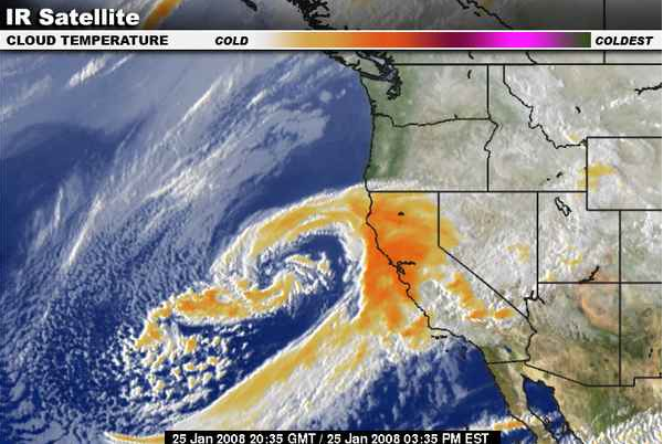
這是從 Weather.com 剪下來的一小時前的衛星雲圖。這個暴風雨直直往 Monterey Bay 襲來,前幾天的冷空氣已經為附近山上帶來許多雪,昨晚開始下大雨颳大風。(那個有一半被橘色暴風圈籠罩的長條就是加州,北加州有一小坨歪歪扭扭的海岸線伸進陸地,就是舊金山灣,在我家北方 90 分鐘車程)
我們一月初從台灣返回美國的時候,剛好也有一個暴風雨,整個西海岸都在暴風圈內(從西雅圖到聖地牙哥)。雖然我們回來的時候暴風已經過去,但大家都談論著風雨的可怕:停電24小時、溪水暴漲、大樹搖搖欲墜、17 號封路...。宿舍區後的小山坡有幾棵大樹被砍掉了,圍了施工的黃布條,我們一開始也不知道為什麼要砍樹,後來發現有工人在修屋頂,才知道原來是有樹倒下來把兩間宿舍的屋頂壓壞了!天啊,還好我家後面的樹不太高大....
A stronger second storm has taken up residence off the California Coast and will waffle westward and then southward offshore this weekend before heading inland.(所以比上次那個暴風更強烈?)
Heavy rain will target northern and central California into Saturday. The coastal range and lower flanks(兩側) of the Sierra could pick up as much as 8 inches of rain.(8英吋差不多就是240公釐的雨量...) Flooding and mudslides(坍方) could become a significant problem. Snow levels will rise to between 3500 and 4000 feet before gradually lowering again.(這句不懂,為什麼雪線會上升?風雨太大雪線就會上升喔?) The higher elevations around Mount Shasta and across the Sieera could pick up an additional 1 to 5 feet of snow.
Later Saturday into Sunday, the heaviest rain will shift into Southern California where Santa Barbara, Ventura and Los Angeles Counties have already received between 2 and 8 inches of rain. The coast, valleys and coastal mountains could pick or again this much rain or more by the end of the weekend. Snow levels will rise to at least 6000 feet which will add melting snow to the excessive rainfall. Flooding and mudslides are already becoming a problem around L.A. especially in the burn areas.
所以這個暴風週末就會影響南加州了。老頭喬恩鳳梨熊逸小竹及所有南加州的朋友,你們也要小心噢!
全站熱搜

 留言列表
留言列表